


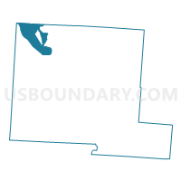
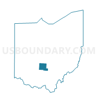
PRECINCT DARBY-NORTH, Pickaway County, Ohio
About
Outline

Summary
| Unique Area Identifier | 650966 |
| Name | PRECINCT DARBY-NORTH |
| County | Pickaway County |
| State | Ohio |
| Area (square miles) | 14.85 |
| Land Area (square miles) | 14.59 |
| Water Area (square miles) | 0.25 |
| % of Land Area | 98.28 |
| % of Water Area | 1.72 |
| Latitude of the Internal Point | 39.76922940 |
| Longtitude of the Internal Point | -83.18696650 |
Maps

Graphs
Select a template below for downloading or customizing gragh for PRECINCT DARBY-NORTH, Pickaway County, Ohio


Neighbors
Neighoring Voting District (by Name) Neighboring Voting District on the Map
- PLEASANT-C Voting District, Franklin County, OH
- PLEASANT-E Voting District, Franklin County, OH
- Precinct Darby Clarks Lake, Pickaway County, OH
- PRECINCT DARBY-SOUTH, Pickaway County, OH
- Precinct DARBYVILLE MUHLENBERG, Pickaway County, OH
- PRECINCT FAIRFIELD SOUTH, Madison County, OH
- Precinct SCIOTO-NORTH/ORIENT, Pickaway County, OH
- Precinct SCIOTO-SOUTH, Pickaway County, OH
Top 10 Neighboring County Subdivision (by Population) Neighboring County Subdivision on the Map
- Scioto township, Pickaway County, OH (9,933)
- Pleasant township, Franklin County, OH (6,671)
- Darby township, Pickaway County, OH (3,366)
- Fairfield township, Madison County, OH (1,437)
- Muhlenberg township, Pickaway County, OH (901)
Top 10 Neighboring Place (by Population) Neighboring Place on the Map
Top 10 Neighboring Unified School District (by Population) Neighboring Unified School District on the Map
- South-Western City School District, OH (133,296)
- Teays Valley Local School District, OH (22,621)
- Madison-Plains Local School District, OH (11,154)
- Westfall Local School District, OH (8,651)
Top 10 Neighboring State Legislative District Lower Chamber (by Population) Neighboring State Legislative District Lower Chamber on the Map
- State House District 23, OH (135,650)
- State House District 85, OH (125,655)
- State House District 84, OH (116,799)
Top 10 Neighboring State Legislative District Upper Chamber (by Population) Neighboring State Legislative District Upper Chamber on the Map
- State Senate District 16, OH (388,173)
- State Senate District 17, OH (360,811)
- State Senate District 10, OH (343,341)
Top 10 Neighboring 111th Congressional District (by Population) Neighboring 111th Congressional District on the Map
Top 10 Neighboring Census Tract (by Population) Neighboring Census Tract on the Map
- Census Tract 98, Franklin County, OH (6,745)
- Census Tract 214.02, Pickaway County, OH (6,335)
- Census Tract 411, Madison County, OH (4,761)
- Census Tract 213, Pickaway County, OH (3,598)
- Census Tract 214.01, Pickaway County, OH (3,366)
- Census Tract 215, Pickaway County, OH (3,267)